A narrow ridge of land in Terrebonne Parish became the site of the nation's first federally funded climate relocation. Nearly a decade later, the results are still contested - and instructive.
Ani Catherine | July 12, 2026
If you have heard Isle de Jean Charles mentioned lately, on a podcast, in a documentary, in passing, you may have caught fragments: a community moved off the coast, a road that floods, camps where homes used to be. The fragments are real, but they add up to a more complicated story than any single one suggests. Here is what actually happened, in order, and why people well beyond southern Louisiana are paying attention.
The place and its people
Isle de Jean Charles (locally, Isle à Jean Charles) is a thin strip of land in Terrebonne Parish, about 80 miles southwest of New Orleans, connected to the mainland by a single two-lane road. For roughly 170 years it was the home of a Native American community - the ancestors of today's Jean Charles Choctaw Nation and the Isle de Jean Charles Band of Biloxi-Chitimacha-Choctaw. Some of those ancestors settled the island in the 1830s, moving to remote swampland to escape the Indian Removal Act and the Trail of Tears.
One point of frequent confusion is worth clearing up. The island community is Native American, not Black. The mix-up has a real source: on early census records, white record-keepers often labeled the island families as "Mulatto" or "Negro," and the community's own history begins with the marriage of a Frenchman, Jean Marie Naquin, to a Native woman, Pauline Verdin. But the families identify, and have always identified, as Native American. Some tribal members even recalled being pressured to change "Indian" to "white" on school forms so their children could attend segregated schools before integration.
Why the land vanished
The island once encompassed more than 22,000 acres. Today roughly 320 remain - a loss of about 98 percent. That collapse was not a single event but a compounding one.
Beginning in the 1940s, oil and gas companies dredged canals through the surrounding marsh for wells and pipelines. Those canals let saltwater push inland, killing the freshwater cypress, willows, and live oaks that once defined the island, along with the pastures and gardens families farmed. At the same time, levees built upriver on the Mississippi cut off the sediment that used to replenish the delta, so the land began to sink - a process called subsidence, which oil extraction accelerated. Add rising seas and a steady procession of hurricanes, and a forested, farmable ridge became a bare sliver washing into the Gulf. Residents who grew up there describe opening a back door once framed by cattle and cotton, and opening the same door now onto open water.
The road that floods
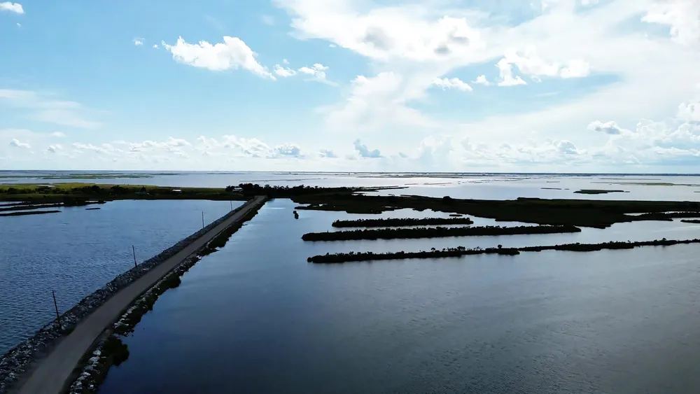
The island's lifeline is Island Road, built in 1953. Before it existed, the only way on or off was by boat. It is often described as a bridge because, at high tide or in a south wind, the Gulf swallows it and it simply disappears beneath the water. For residents, that meant being routinely cut off from work, school, and medical care. And when the Army Corps of Engineers designed the Morganza-to-the-Gulf levee system to protect the region, a cost-benefit analysis left Isle de Jean Charles outside the wall — the Corps even projected the new levees could raise storm water levels on the island. By the early 2000s, the community understood it would not be protected in place.
The relocation
In 2016, the state of Louisiana won a $92 million federal grant through a national disaster-resilience competition, using about $48 million to move the community to higher ground. It was the first time the federal government fully funded the relocation of an entire community because of climate change - a project meant to be a national model.
The state, through its Office of Community Development, bought 515 acres of farmland near Schriever, roughly 40 miles north, for $11.7 million. In 2019 residents named the new community The New Isle: 37 homes on raised foundations, well above the 500-year floodplain. The state emphasizes that participation was voluntary and that residents had extensive input into the site selection.
That is where the account of a clean success ends and the disputes begin.
Where it gets contested
Who the move was for. The original vision, developed over more than a decade with the tribe and a nonprofit partner, was to reunite the tribe as a community. After a second tribe sought to include its members living on the island, the state set eligibility by residency and 2012 hurricane displacement rather than tribal membership. Tribal leaders say this ended the original purpose and cut them out of decisions; the state says it was legally unable to run the project as a tribe-only effort and had to balance individual residents' wishes against tribal leadership.
What happened to the old homes. Residents who accepted a New Isle home signed agreements barring them from living in, renting, substantially repairing, or freely selling their island property. The homes may still stand, but their former owners cannot use them.
The safety contradiction. The entire project rested on the premise that the island is too unsafe to inhabit. Yet as residents were restricted from improving their own properties, the state's Department of Wildlife and Fisheries put roughly $3 million into shoring up Island Road and adding a boat launch and fishing piers, promoting it as a destination for anglers. A Houma developer subsequently proposed a subdivision of fishing cabins. The tribe's 2023 federal civil rights complaint points to more than $50 million in state investments protecting the island - a ring levee, rock armoring along Island Road, marsh creation, piers, and parking - and argues those measures show the "too dangerous to live here" rationale was applied selectively: withheld from Native residents, then provided once the land was cleared for recreational use. The state's position is that these investments protect a public road and boat launch open to everyone. Both the dollar figures and the sequence are documented; the intent is what the complaint alleges and what remains unproven.
The homes. Residents have reported leaks, plumbing that appeared never to have been properly connected, and other defects in the new houses, and some accuse the state of rushing construction and ignoring their input. The state says warranty claims were resolved.
The water that isn't a fishery. For families who lived off shrimp, crab, and fin fish for generations, designers dug out an existing bayou into a water feature, "Bayou Blue," so residents could still fish near home. In practice, the manufactured waterway does not hold the species they relied on. Recent reporting describes grant money spent on water they do not want to fish in. As researchers note, you can move people inland and even dig them a pond, but you cannot relocate a brackish estuary - or the knowledge, work, and identity built around it.
Why it matters
Louisiana's own officials have declined to call the relocation a success, and some residents put it more bluntly, telling national reporters they would not recommend the experience to anyone. That verdict carries weight far beyond one island.
Louisiana loses a football field's worth of land roughly every 100 minutes, and by some estimates 2.5 million Americans could face relocation from vulnerable coastlines over the next 25 years. Isle de Jean Charles was supposed to be the template for how that is done well — with enough money, enough time, and a willing community. If a small, cohesive community with tens of millions of dollars and years of planning still ended up with a fractured tribe, a substandard build, a dead fishery, and a federal civil rights complaint, the lesson researchers keep drawing is sobering: managed retreat is not primarily a logistics problem - it is a human one. Skills, social networks, and livelihoods take years to rebuild, which is why they argue the planning has to start long before a place becomes unlivable.
Photo Credit: CreoleSky Aerial
Reporting drawn from the Louisiana Illuminator, Inside Climate News, ICT, nola.com | The Times-Picayune, WWNO, and the Center for Public Integrity; the Louisiana Office of Community Development's project record; and the Jean Charles Choctaw Nation's 2023 Title VI civil rights complaint filed with support from EarthRights International.
Ani Catherine writes where power is exposed rather than explained. Her work examines history, public memory, identity, and institutional authority with a focus on what is preserved, what is erased, and who benefits from the distinction. Through commentary and analysis, she explores government, culture, religion, race, and systems of influence with a commitment to evidence, accountability, and historical context. She believes language is never neutral, memory is never accidental, and silence is often policy. Staff Writer.
© 2026 Evans Cutchmore Press. All rights reserved.